Recent Activities
Esperance Tjaltjraak Native Title Aboriginal Corporation and Ornithological Services collaboration project
Following the flight of the Yowli
November 2025 saw OTS begin an ongoing partnership with the Esperance Tjaltjraak Native Title Aboriginal Corporation (ETNTAC). Tjaltjraak: Pronounced "Dul-u-rak" this is the Wudjari name of the local blue gum tree; which means "Glow in the Dark". Tjaltjraak is a culturally significant species of eucalypt, the geographic distribution of which roughly aligns with the boundaries of Kepa Kurl Nyungar Country.
In partnership with the Sea Ranger department of ETNTAC we have developed a banding project investigating the migration of the Short-tailed Shearwater (Yowli) which breeds on the islands off of Esperance.
The Flight of Yowli project has many cultural aspects to its structure, which is unusual in a bird banding project. Some of the long-term goals are summarised below,
The Flight of Yowli project is distinguished by its integration of cultural considerations into the project framework, which is uncommon in traditional bird banding initiatives. Key long-term objectives are outlined below.
Following the Flight of Yowli
· Utilise GIS and spatial modelling to map emerging flyway patterns.
· Identify significant ecological zones, migration bottlenecks, and oceanographic features.
· Investigate connections between migratory routes and cultural seascapes, with a focus on recognising Alaskan cultural regions associated with the birds.
· Engage with relevant Tribal organisations and cultural representatives in Alaska.
· Establish an ETNTAC Sea Ranger Bird Banding team.
· Facilitate online knowledge exchange sessions between project personnel and Alaskan cultural representatives.
· Coordinate with ornithological groups in the USA (Alaska and Montana) to broaden collaborative networks.
· Develop a biocultural flyway corridor model connecting key regions: Kepa Kurl and Alaska.
· Root the programme in Indigenous-led stewardship through cultural ranger networks.
· Merge monitoring systems (satellite tracking, ARUs, oceanographic data) with traditional knowledge frameworks.
· Align project outcomes with international policy instruments, such as the United Nations High Seas Treaty (BBNJ Agreement), positioning the flyway as a candidate for transboundary conservation corridor designation.
· Produce a final project film and interactive story map to document the journey, partnerships, and findings.
· Present the programme as a flagship biocultural initiative to funding agencies and international forums.
There is still much work to be done in this area, with the birds themselves being central to these efforts. In March 2026, the Yowli tracking component began. The ETNTAC Sea Ranger team and two OTS ornithologists conducted fieldwork on Wickham Island, fitting four birds with GPS satellite trackers and 16 with geo-locators. The GPS trackers provided immediate movement data, while the 16 geo-locator birds will be recaptured at their nesting burrows in November 2026.
As with many similar projects, equipment failure or birds removing their tags can be an issue, and the Yowli project faced the same challenges. Of the four GPS trackers, one stopped working on the first day and another after about a month. However, the team still captured valuable images of the birds' remarkable journeys. Some tracks are shown below—enjoy!
April 7th, 2026
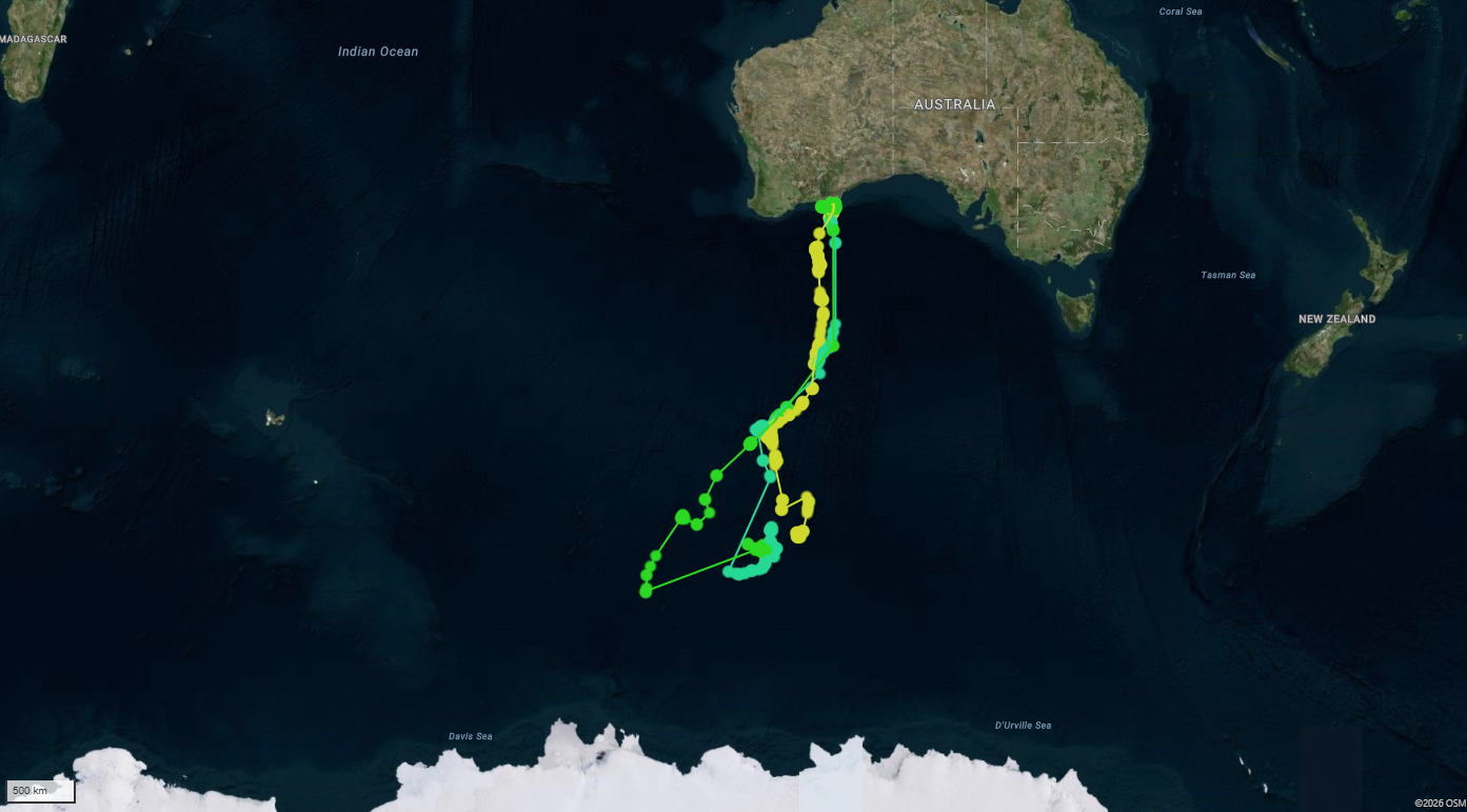
On their release on March 26th 2026 the birds headed south very quickly and then spent over a week feeding in an area known as the Antarctic convergence zone. This area, also called the Antarctic Polar Front, is a dynamic boundary encircling Antarctica, characterised by a zone of downwelling and upwelling that creates nutrient rich waters attractive the Yowli’s prey species. The Antarctic continent can be seen at the bottom of the above image. It seems we lost one of the four GPS transmitters very early on in the process, as by the second day only three transmitters were transmitting data.
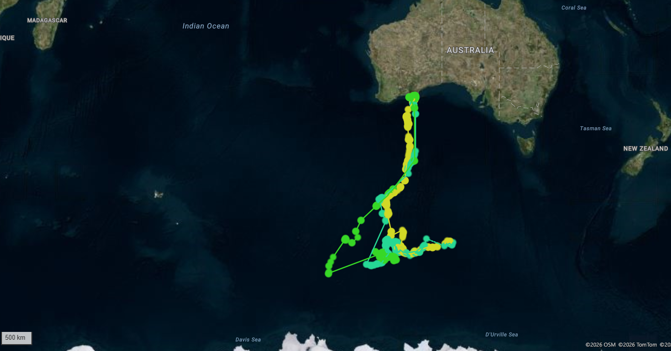
By the 17th of April two of the birds had begun to drift east. It was on this date that we lost the second of our transmitters, which is likely still floating around the Antarctic Convergence Area, maybe still with the two tail feathers it was attached too.
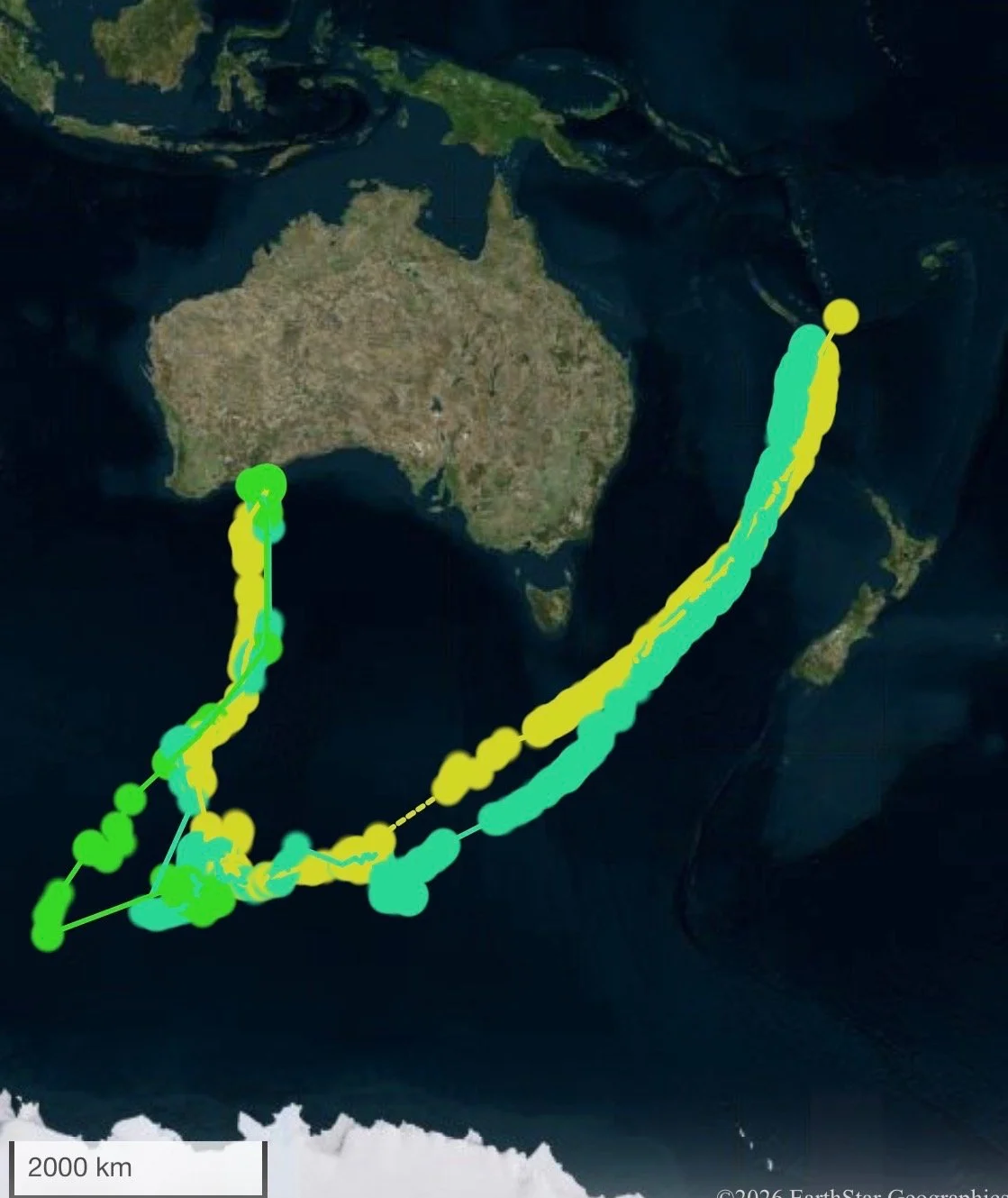
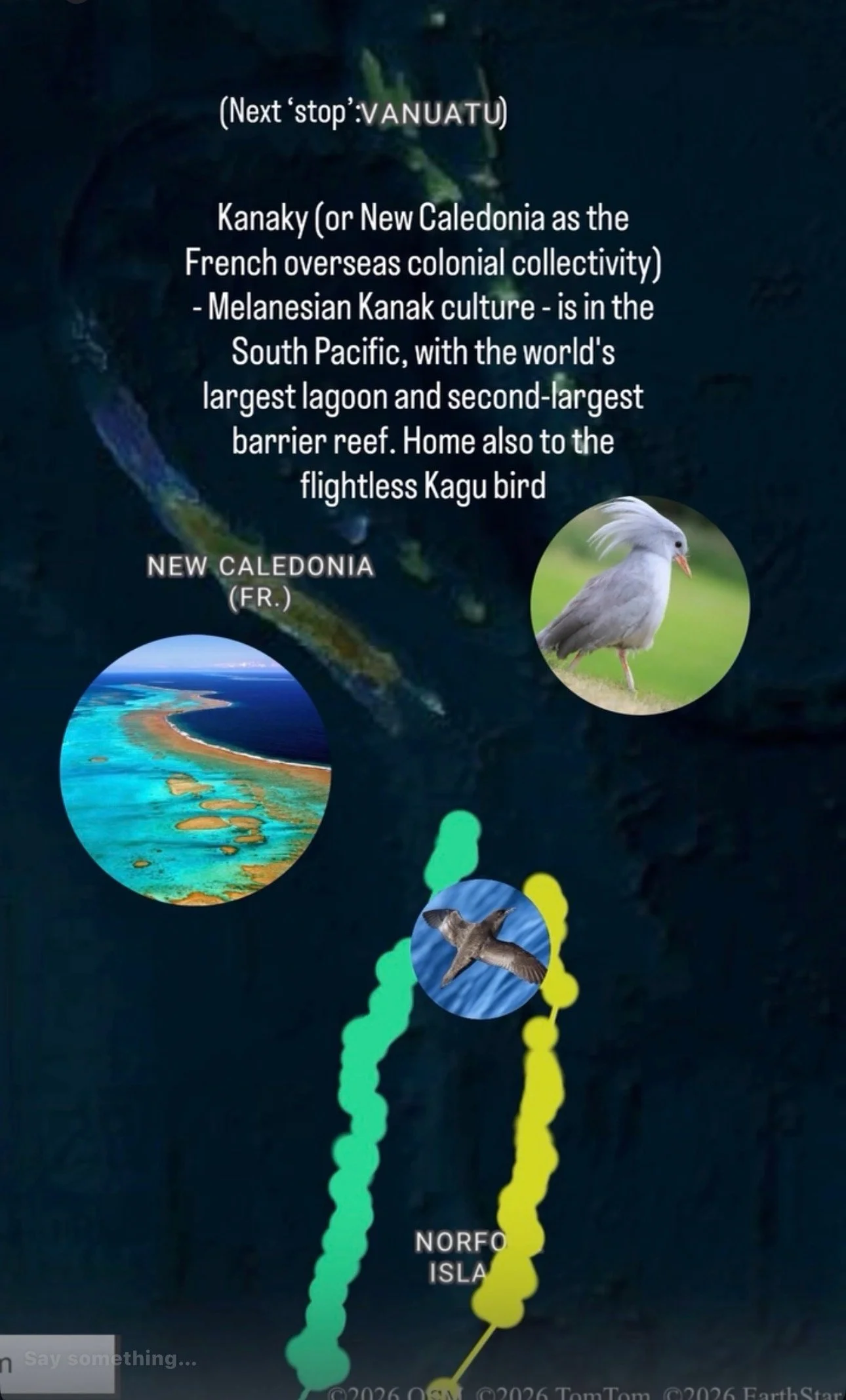
April 20th saw a very exciting development. The two remaining birds with transmitters had left the Southern Ocean and raced across the Tasmin Sea and into the South-West Pacific Ocean. The birds were adjacent to New Caledonia when we received their signal.
The birds were outpacing our ability to stay up to date with their movements and what cultural boundaries they were crossing. We managed to put this information slide together, but it had been left behind by the time we posted.
When we caught up with the birds again, they had left the southern Pacific Ocean and were well and truly on their way to their non-breeding grounds where they will moult and loose the transmitters we have fitted.
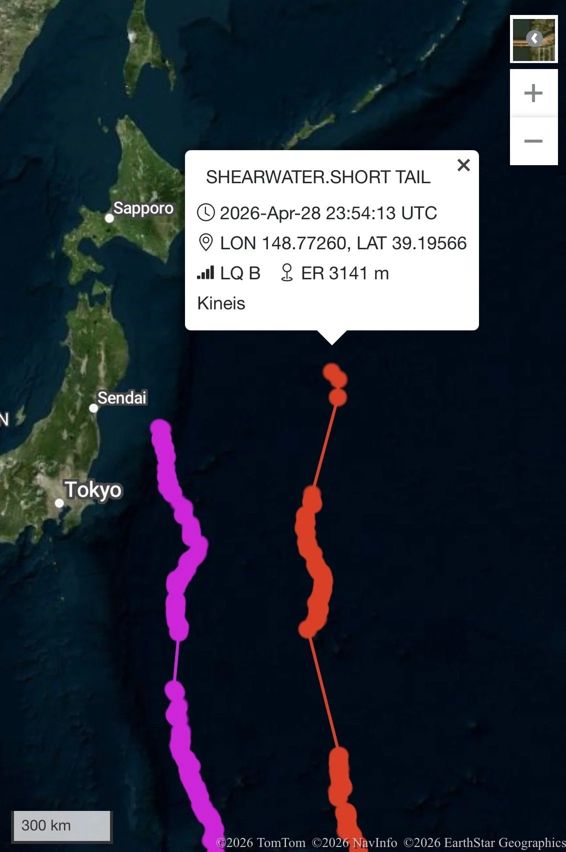
April 29th, 2026.
By April 29th the birds had crossed the equator and Tropic of Cancer and were heading due north adjacent to the coast of Honshu Island Japan!!
OTS Aviation Industry Award
We are happy to announce that we have been selected for a Certificate of Commendation by the Australian Aviation Wildlife Hazard Group. The award is in recognition of innovation and communication software relating to wildlife monitoring data. OTS is the first Western Australian company to receive an award from the AAWHG. Our Weekly Bird Count Report (WBCR) software is used at over 15 airports here in Australia, and in New Zealand by Auckland International Airport. The software generates weekly statements on risk trends relative to a given airport’s overall risk register.

Auckland Landside Integration
OTS has recently expanded its activities at Auckland International Airport to include Landside development projects. We are currently working in partnership with Fulton & Hogan on the P&R Phase 1 Project. The 4,000-space car park is directly beneath the 23L Runway approach and OTS are required to monitor and disperse birds, particularly Kelp Gull, from the site, which are attracted to the site by the earth works and water features needed for such projects.
![IMG_0358[50751].JPG](https://images.squarespace-cdn.com/content/v1/5d5f5870fa4fba0001394b28/1581572493568-5M9TTPR1MS02GXT5EHLJ/IMG_0358%5B50751%5D.JPG)
Shorebird Surveying
OTS has been conducting surveys for three separate projects in the shorebird hot-spot of north-west Western Australia. Of the three projects one required shore-based observations and data collection, the remaining two required aerial surveys from helicopters. Such surveys require early starts and run for most of the day, spanning both low and high tides at a site. These long and tiring days are hard work but can produce some amazing results including over 65,000 shorebirds and terns counted in one day of survey work recently.

Aerial view of a flock of migratory shorebirds flying over the coast at high tide in north-western Australia.
SILVER GULL BANDING PROJECT
OTS has recently started a colour banding project looking into the movements of Silver Gulls in the Perth Metro Area. To date OTS has banded 28 gulls on Rottnest Island using alphanumeric coloured bands which are readable in the field. This project began in early 2021 and since then has resulted in the resighting of 15 birds, some seen repetitively around Rottnest Island. Recently we have received records from the general public showing how far our banded Silver Gulls will travel away from Rottnest Island. Our longest distance record was from Scarborough Beach recorded, almost 25km away. This is a great record, and potentially the first documentation of Silver Gulls traveling between Rottnest Island and the mainland.

Map displaying how far away out colour banded Silver Gulls have been reported from our banding site on Rottnest Island.
We would like to thank the observers who have already submitted their resighting data and thank in advance any observers who will do so in the future. We would ask any resightings of these birds be reported to billrutheford@ornitech.au. All information valuable even if exact letters and numbers are not recorded.
Wedge-tailed Shearwater Banding project
OTS operates a waterbird and seabird banding project for south-western Australia. In 2021 we conducted two sessions of mist netting to catch Wedge-tailed Shearwaters on Rottnest Island. This is the only banding project in Australia which has caught adult Wedge-tailed Shearwaters as the standard method is to band nestlings whilst they are still in their nests. This project has produced invaluable information on the morphology and moult patterns in Wedge-tailed Shearwaters, as the most recently published data is over 50 years old. This data is the only record of morphology recorded on adult Wedge-tailed shearwaters in Australia for the subspecies Puffinus pacificus chlororhynchus, according to the Handbook for Australian, New Zealand and Antarctic Birds.

OTS staff and volunteers banding Wedge-tailed Shearwaters on Rottnest Island.